|
Reported Crop Circles for the State
of Montana -
Kalispell / Whitefish, Flathead County (August 14, 2000)
A pilot flying over the formation reported that his compass swayed 15 degrees as he passed over it the first time at about a 500' altitude; subsequent passes over resulted in compass deflections of around 10 degrees repeatedly. The lay was counterclockwise. Other E-M effects reported.
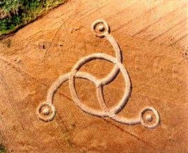
Crop
type: wheat
Source: Jeffrey Wilson
|
|
City
/ County / Date:
- Cascade County (1976)
- Volborg, Custer County (1987)
- [Unknown] (January 1, 1991)
- Butte, Silver Bow County
(July 25, 1998)
- Kalispell / Whitefish, Flathead County (August 25, 1998)
- Kalispell / Whitefish, Flathead County (September 4, 1999)
- Kalispell / Whitefish, Flathead County (August 14, 2000)
- Kalispell / Whitefish, Flathead County (August 25, 2000)
- USDA Fort Keogh Livestock and Range Research Laboratory, Miles City, Custer County
(August, 2002)
- USDA Fort Keogh Livestock and Range Research Laboratory, Miles City, Custer County (October, 2003)
|


